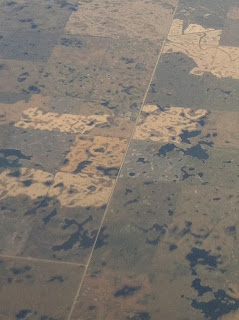
Before I go any further I should probably make three points clear. Firstly, I know that the economies of the provinces of Saskatchewan and Manitoba are not exclusively agricultural. Secondly, I also know that these provinces are huge and that the terrain differs from region to region (i.e. that there are at least a few hills in each of these provinces). And, thirdly, that I know I saw only a relatively small portion of either of these provinces (though on my various flights I did probably see hundreds or thousands of square kilometres of each province).
That said, to reiterate, what I did see was overwhelmingly flat land devoted to agricultural production. There were literally farms as far as the eye could see.
I couldn't help but wonder if there is more land devoted to agriculture in this photo than in all of Newfoundland and Labrador?
And if I focused more closely on a specific area it was pretty easy to see what was going on on the ground.
At times, particularly in Saskatchewan, some of the fields/regions were a little more pock marked. I still don't know exactly what was going on in these situations.
And maybe it's just me and my unfamiliarity with prairie farming, but I kind of thought that the farms just outside of Winnipeg looked a little different than the farms near Regina. But again, maybe that's just my unfamiliarity with prairie farming.
I was particularly pleased with myself when I found the line in the land a little east of Winnipeg where the farming, or at least the overwhelming predominance of farming, basically comes to an end and forested areas pick up. Until yesterday I had no idea that such a line even existed - I had always assumed the farming gradually lessened.
And isn't it also nice to see a little of the earth's curvature?


No comments:
Post a Comment